Fifty years ago, three remarkable women convinced the State of California to create the world’s first coastal protection agency – BCDC. Kay Kerr, Sylvia McLaughlin, and Esther Gulick looked west from their East Bay living rooms and saw a shoreline and wetlands being defiled by garbage and development. The Bay was endangered – an average of four square miles of the Bay had been filled during each of the previous 110 years. Action was needed, and the three women founded the Save San Francisco Bay Association (now known simply as Save the Bay).
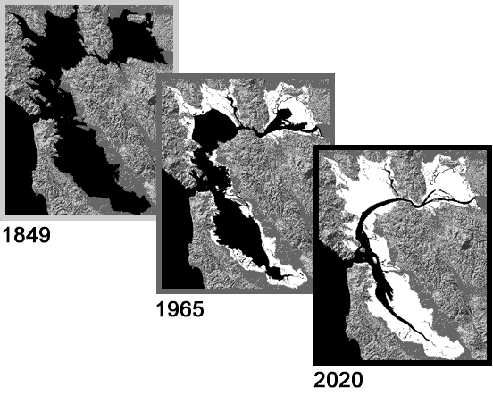
Filling the Bay certainly was not a new endeavor. For years, the Bay had been filled to provide more space for ports, industry, airports, houses, and garbage dumps (both formally and unofficially). Three factors make San Francisco Bay especially susceptible to being filled: much of the Bay is very shallow (about two thirds of it is less than 18 feet deep); large portions of the Bay bottom along the shoreline are in private ownership; and, political control of the Bay is fragmented among scores of public agencies and jurisdictions. In 1849, as California’s Gold Rush was beginning, the Bay was 787 square miles in size. Today it is approximately 550 square miles. One plan, promoted by the U.S. Department of Commerce in the late 1950s looking forward 75 years, would have resulted in about 325 additional square miles of fill. The Bay would have become little more than a broad river.
At Save the Bay’s urging, the McAteer-Petris Act was enacted in 1965. It established BCDC as a temporary state agency, designated the San Francisco Bay as a State-protected resource, and charged the Commission with preparing a plan for the long-term use of the Bay and regulating development in and around the Bay while the plan was being prepared. BCDC was established as the Nation’s first coastal zone management agency. For purposes of clarity, it should be noted that the estuary known as San Francisco Bay – which comprises BCDC’s Bay jurisdiction – actually is comprised of eight separate bays: Suisun Bay; San Pablo Bay; Honker Bay; Richardson Bay; San Rafael Bay; San Leandro Bay; Grizzly Bay; and, finally, San Francisco Bay itself.
BCDC’s initial San Francisco Bay Plan was approved in 1968 and BCDC was made permanent one year later. The Bay Plan is updated regularly so that the Bay and its shoreline are used responsibly and to address new issues as the Bay Area changes. The Plan includes policies on issues critical to the Bay ranging from port activities and public access to urban development and transportation. The Bay Plan maps the entire Bay and designates areas for water-related purposes such as ports, industry, public recreation, airports, and wildlife refuges.
The McAteer-Petris Act is the key legal provision in California state law to prevent indiscriminate Bay fill. BCDC has permitting responsibility to ensure that appropriate and environmentally sound development provides public benefits and economic development for the entire region. BCDC was not created to obviate or supersede the authority of cities, counties, and special districts that are located along the Bay and its shoreline. Instead, its role is to view the Bay as an entire system, which is impossible for more narrowly focused governmental bodies. Throughout its history, BCDC has learned that its most notable successes are produced by coordinating, collaborating, and/or partnering with governments at all levels and with a wide variety of other stakeholders. This cooperation is vital given that BCDC’s jurisdiction for public access issues extends 100 feet from the Bay through immediate shoreline starting at mean high tide.
In 1977, California expanded the Commission’s authority to provide special protection for the Suisun Marsh. The Marsh is the “mixing zone” that connects the Bay with the Delta. It is the largest contiguous brackish marsh on the west coast of North America; more than 10% of California’s remaining wetlands and more than 300 species, including 80% of the State’s commercial salmon fishery, are found in the marsh. Therefore, BCDC has a great incentive to work closely with the organizations and interests that are associated with Bay and Delta water issues. The environmental, economic, and social connections between and among the Bay, the Suisun Marsh, and the Delta should be understood as assets to all residents of the greater Bay Area and California, and they are all subject to climate change.
Today, BCDC’s accomplishments are evident all around the Bay and within its shoreline. Before BCDC was created, families didn’t stroll on bayside trails because none existed. The shoreline was filled with garbage dumps, industrial development, and little else. The Bay’s wetlands and wildlife were vanishing.
After fifty years of groundbreaking stewardship, the size of the Bay has increased significantly. The Bay hosts the nation’s largest urban wildlife refuge and thousands of acres of permanently protected diked former Baylands. The Bay shoreline is now fringed by hundreds of miles of trails, parks, beaches, promenades and restoration projects – even in heavily urbanized and industrial locales. In 1965, opponents of the proposed McAteer-Petris legislation argued that saving the Bay could only be achieved at the cost of sacrificing economic growth. Contrary to this fear, the Bay Area economy has continued to expand, in part because the Commission has approved billions of dollars of construction and worked with local governments on special area plans to encourage appropriate new development.
BCDC is the federally-designated state coastal management agency for the San Francisco Bay segment of the California coastal zone. This designation empowers the Commission to use the authority of the federal Coastal Zone Management Act to ensure that federal projects and activities are consistent with the policies of the Bay Plan and state law.
Twenty-seven individuals sit as Commissioners. They represent a wide variety of public, private, and nonprofit sector interests. The Governor appoints the Chair and Vice-Chair, along with three other individuals. County Supervisors represent each of the nine counties that touch the Bay, elected officials represent four bayside cities, and other Commissioners represent state and federal agencies with an interest in Bay issues.