BCDC's jurisdiction
BCDC is a state agency with land use planning and regulatory authority over San Francisco Bay and the Suisun Marsh. BCDC has several types of jurisdiction under state law.
How it works
Under state law
BCDC’s jurisdiction is established in 2 state laws:
BCDC’s administrative regulations also clarify certain questions about BCDC’s jurisdiction.
Under federal law
BCDC has authority under the federal Coastal Zone Management Act to review activities by federal government agencies that could affect the Bay.
- This review happens through a process called “federal consistency” review
- This review can consider development projects and activities that happen outside of BCDC’s state permitting jurisdictions, if they have potential effects on the Bay
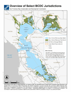 Jurisdiction at a glance
This map gives an overview of select BCDC jurisdictions. It is for communication purposes only. Some boundaries were over-estimated to encourage collaboration with BCDC staff. Check our Maps and Data page to learn more.
BCDC’s jurisdiction under the McAteer-Petris Act
Under the McAteer-Petris Act, BCDC has 5 jurisdictions. Click on each card to find out more:

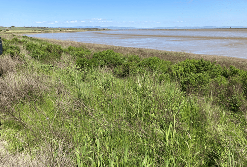
San Francisco Bay
Including its open waters, marshes, and mudflats. Also tributaries to the Bay where they are influenced by tides.

Managed wetlands
Wetlands that were diked off from the Bay in the past to create duck hunting habitat and for agricultural uses.

Shoreline band
The first 100 feet inland from the shoreline around San Francisco Bay and its tidally influenced tributaries.
Certain waterways
Segments of certain creeks and rivers that flow into the Bay.

Salt ponds
Areas that were diked off from the Bay in the past so they could be used for producing salt.
San Francisco Bay
BCDC’s San Francisco Bay jurisdiction (or Bay jurisdiction) includes:
…all areas that are subject to tidal action from the south end of the bay to the Golden Gate (Point Bonita-Point Lobos) and to the Sacramento River line (a line between Stake Point and Simmons Point, extended northeasterly to the mouth of Marshall Cut), including all sloughs, and specifically, the marshlands lying between mean high tide and five feet above mean sea level; tidelands (land lying between mean high tide and mean low tide); and submerged lands (land lying below mean low tide).
The San Francisco Bay estuary is the largest estuary on the west coast.
The area of the Bay is 550 square miles, 1.2 times the size of the City of Los Angeles.
Shoreline band
BCDC’s 100-foot wide shoreline band jurisdiction (or shoreline band) includes:
… all territory located between the shoreline of San Francisco Bay … and a line 100 feet landward of and parallel with that line …
Bay Plan priority use areas in the shoreline band
BCDC’s San Francisco Bay Plan designates certain shoreline areas for priority uses, including:
- Ports
- Water-related industry
- Airports
- Wildlife refuges
- Water-related recreation (waterfront parks, beaches)
The Bay Plan maps show the boundaries of priority use areas, and this information is also available on BCDC’s open data portal. The Commission adopted Resolution 16 (updated April 20, 2023) to more specifically define the boundaries of priority use areas within the shoreline band.
San Francisco Bay’s shoreline is approximately half the length of the total California coastline.
Salt ponds
BCDC’s salt pond jurisdiction includes:
all areas which have been diked off from the bay and have been used during the three years immediately preceding the effective date of the amendment of this section during the 1969 Regular Session of the Legislature for the solar evaporation of bay water in the course of salt production.
Managed wetlands
BCDC’s managed wetlands jurisdiction includes:
all areas which have been diked off from the bay and have been maintained during the three years immediately preceding the effective date of the amendment of this section during the 1969 Regular Session of the Legislature as a duck hunting preserve, game refuge or for agriculture.
Certain waterways
BCDC’s certain waterways jurisdiction includes:
all areas that are subject to tidal action, including submerged lands, tidelands, and marshlands up to five feet above mean sea level, on, or tributary to, the listed portions of the following waterways:
(1) Plummer Creek in Alameda County, to the eastern limit of the saltponds.
(2) Coyote Creek (and branches) in Alameda and Santa Clara Counties, to the easternmost point of Newby Island.
(3) Redwood Creek in San Mateo County, to its confluence with Smith Slough.
(4) Tolay Creek in Sonoma County, to the northerly line of Sears Point Road (State Highway 37).
(5) Petaluma River in Marin and Sonoma Counties to its confluence with Adobe Creek, and San Antonio Creek to the easterly line of the Northwestern Pacific Railroad right-of-way.
(6) Napa River, to the northernmost point of Bull Island.
(7) Sonoma Creek, to its confluence with Second Napa Slough.
(8) Corte Madera Creek in Marin County to the downstream end of the concrete channel on Corte Madera Creek which is located at the United States Army Corps of Engineers Station No. 318+50 on the Corte Madera Creek Flood Control Project.
Areas excluded from BCDC’s jurisdiction under the McAteer-Petris Act
BCDC’s jurisdiction does not extend to the areas commonly known as the Larkspur Boardwalk and Greenbrae Boardwalk in the County of Marin.
BCDC’s jurisdiction under the Suisun Marsh Preservation Act
There are 2 jurisdictions under the Suisun Marsh Preservation Act:
- The primary management area: 89,000 acres of tidal marsh, managed wetlands, adjacent grasslands, and waterways
- The secondary management area: 22,500 acres of significant buffer lands
Development in either jurisdiction requires a permit called a “marsh development permit.”
- BCDC issues permits in the primary management area
- Local governments issue permits in the secondary management area (this decision can be appealed to BCDC in some cases)
The primary and secondary management areas are mapped. You can see their extent on this interactive map: >
The Suisun Marsh is the largest brackish-water marsh west of the Mississippi River.